Description:
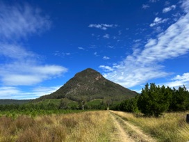
The Beehive (or South Obelisk, or Callawajune Mountain) is located just south of Tooloom Falls, in Urbenville, NSW. In my 20's I often visited the area with my flatmate. His mum lived up the road towards Urbenville and we'd come up and visit. I remember looking the Beehive, and the other peaks close by - and thinking I'd love to climb one, one day.
Fast forward 20+ years and the thought had left my mind until searching for local trigs that could be fun to visit.
So this one is back on the list.
Resources:
GPX File: includes parking, trail head and summit - plus a track file from a hiker that successfully made it to the top.
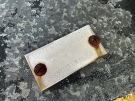
Survey Sketch: Survey notes regarding the trig station at the summit.
Hike Recommendations:
Gear: Hiking Pole - May help with the return back down the mountain
Parking: Easy access to parking location. Urbenville to Connells Road. Into the State Forest and onto Gooroobee Road, then forward to Beehive Road.
Season: Winter. Would be a nice way to warm up on a crisp winters morning, and shouldn't accidentally run into any snakes on route.
Biggest Challenge: Steep climb.
This map was created using
GPS Visualizer
's do-it-yourself geographic utilities.
Please wait while the map data loads...
Progress Notes:
8/Apr/2023: Trip to the area with NT to check out the accessibility. Sunny day, but winds were high. We climbed up close to half way, but decided that it was too much for today, and the high winds were worrying. Wasn't sure about fitness levels, but found the downhill a lot easier than expected so will keep this on the list to do in the late Autumn or Winter 2023. I'd like company for this one, for safety reasons, and it would be a good accomplishment to celebrate with a fellow hiker. The company I had today was made the day even more enjoyable. Wouldn't be the same on my own.
I really look forward to attempting this one again and reaching the summit. Not sure why this hill tempts me so much, but it places itself high on the priority list.
12/Apr/2023: After scoping out the area last weekend I decided I’d like to tackle this one again soon. Once upon a time you’d say to yourself that there’s no rush to climb a mountain or explore a national park… they’ll always be there - but that’s not the case anymore. So many National Parks are closing their walks and mountains to visitors, so I decided to come back today and make an attempt to get to the top of the mountain.
I think the trek to the top can be summarised in four steps, all about equal length in distance - maybe not so much in time:
1. After leaving my car at S 28° 31.547 E 152° 30.543, I made my way to Point Carmel (as Google Maps refers to it) - S 28° 31.850 E 152° 30.518. This is simply a point where you can leave the vehicular track and start your climb upward. It’s marked with a small stone cairn at the moment.
2. A thin track from Point Carmel to a large rocky area in which there’s a small cavern isn’t difficult to navigate. You start in some thin Lantana and progress to a wooded area, climbing the natural stone staircase as you ascend.
3. From this area you keep going up, but the trail slowly disappears into thickets of grass, small grass trees and fallen branches. I followed a GPX track I found online, which have me a sense that I was climbing up the best way possible. Some areas were tougher than others. Eventually you’ll arrive at a large rock platform you can climb that has amazing views of the area. They truely are spectacular. You can peer down at where you parked your car and appreciate the elevation you’ve gained. This point has been submitted as Point Esme to Google Maps, keeping in line with the old lady names for the other ‘point’ on this list. It’s at S 28° 32.115 E 152° 30.628.
4. Once you’ve climbed back down from the ledge with the views, it’s up again, in a less wooded area - still no trail, but easy navigation to the summit. I found this the easiest part of the climb. The summit is littered with eroded rock.
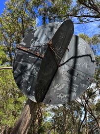
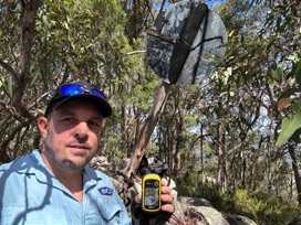
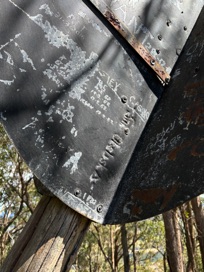
The trig is at the top, albeit with a bit of a lean but vanes and post are holding strong. Plenty of peoples initials engraved on it. The latest date looks to be 2016, but there’s some people who have etched the year 1982 onto the vanes. The rock cairn must be holding the pole in well, as I imagine winds and storms could be quite violent up here. There’s only limited views at the summit, as vegetation has grown and is blocking some of the vista. You can also see many of the trees were sawn off up here a long time ago - I imagine a clearing exercise to assist with the trig being used, but most stumps have shot new branches and have grown back into decent sized trees.
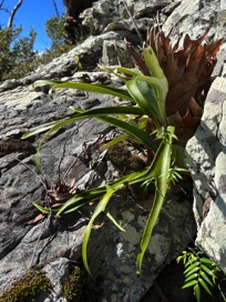
I also read that there’s a critically endangered plant that grows up here, and on the mountain next door - but nowhere else. Phebalium speciosum. I think I actually found a couple of them, but they weren’t in flower so I can’t be 100% sure. They were just up from the little cavern located at the first set of big rocks you encounter on the trip. Apparently they have the ability to grow thick enough they can prevent Lantana from being productive.
It was a good hike - missed my hiking buddy though, it was a very quiet walk up the hill with surprisingly few animals. Just ants, a couple of crows and a few flies at the higher elevation. A good walk and another trig done
Current Status:
SUCCESS
Photos:
If you've done this trek, or would like to comment on it, please do so below.
You may attach a photo to your comment if you'd like too.

